Geospatial Technology Competency Model

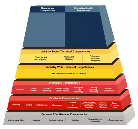
Competency models promote an understanding of the skill sets and competencies that are essential to educate and train a globally competitive workforce. The model for Geospatial Technology Competencies was developed by GeoTech Center and the Employment and Training Administration (ETA) of the Department of Labor.
Originally uploaded in Geoscience in Two-year Colleges:Supporting and Advancing Geoscience Education in Two-Year Colleges:Workforce Development.

Image 35661 is a 426 by 458 pixel JPEG
Uploaded: Sep28 12


Last Modified: 2012-09-28 15:19:21
The file is referred to in 2 pages
Provenance
GeoTech Center and the Employment and Training Administration (ETA) of the Department of Labor
http://www.careeronestop.org/competencymodel/pyramid.aspx?geo=Y
Reuse
This item is in the public domain
and maybe reused freely without restriction.